In recent years, no one doubts the assertion that information is one of
the most valuable resources. The lack of efficient, reliable and complete
information about an engineering and technical object and its geological
environment can often lead to emergency situations, information about which
often appears in mass media. In recent years, a number of design organizations
have been switching to the BIM technology for designing buildings and
constructions because it makes possible to obtain actual information about the
condition of an operated facility at any stage of its life cycle. On its basis,
a well-grounded management decision is made ensuring its further.
safe operation
However, any construction does not
hang "in the air", but rests upon or inside an array of rocks (mines,
subways, underground parking lots, etc.). Therefore, the awareness of the
technical characteristics of the construction is not considered to be sufficient.
For the safety
of operation
it is necessary to
create analytical information systems (AIS) of the construction containing not
only its characteristics but also the parameters of the geological environment.
Thus, there is need to create analytical information systems of the
construction including its characteristics and parameters of the geological
environment, which may also be changed over time.
Modeling the system "Construction
-
Geological Environment" is the task of a specialist in the field of
engineering geology, who can make forecasts of affecting various factors on the
basis of this model. In the work [11], the authors pointed out that due to
visualization (visual presentation of information),
a
geological engineer can evaluate the holistic picture of the researched sphere
to constitute new patterns or to determine inaccuracies arisen.
Visual presentation of geological data can be two-dimensional and 3D.
Two-dimensional visualization of engineering and geological data is usually
represented by sections, well columns and thematic maps. 3D visualization is
more often used in solving some more complicated tasks, constructing volumetric
geological bodies associated with calculating reserves and designing mine
workings.
The most popular software products that provide two-dimensional
visualization of geological and engineering-geological data are automatic
design systems (ADS), such as AutoCAD, Credo,
Geocad,
SurfCad
and Pipeline. These engineering and
geological programs are used mainly for the preparation of the geological
columns and sections. The application of geological information systems (
ArcGis,
Mapinfo,
QGis,
GIS-panorama, etc.) in engineering geology is aimed
at creating maps for various purposes.
For 3D visualization of geological data, almost all the above mentioned
software products can be used, which are referred both to CAD and geological
information systems. However, in order to create and display complex geological
bodies and solve 3D tasks, the packages of 3D geological modeling (
Leapfroq,
Micromine,
Surpac,
etc.) are the most suitable ones. Thus, in the work
[13], the Leapfrog software product is the main tool for making a geological
model and data visualization. However, all of them are rather complicated,
expensive and require additional specialized training.
The geological information systems are sufficient for modeling and
visualizing the data on the natural-technical system “Construction - Geological
Environment”. Thus, in the work [10], the results of the
engineering-geological investigations are presented being visualized by
ArcView. The GIS technologies, the ArcGIS software product is represented in
the work [12] as
the
main tool of the synthesis
and 3D visualization.
In this article, the solution is proposed to create an analytical
information system that provides the 3D data visualization on the basis of the
GIS systems. The tools to work with 3D graphs are implemented quite well within
such systems and make possible to monitor the design decisions adopted at the
new level and to make changes in proper time when errors are detected on the
example of sinking shafts.
In many cases a deposit opening is carried out by vertical shafts during
the underground mining. They open access to working horizons in the shortest
way, load elevation along them is the most convenient, and the expenses are the
lowest. When the depth of the development is large, the deposit opening by
means of vertical shafts is the only possible way. Approximately 95% of
vertical shafts in hard rocks are concreted and have a circular cross section
of 3 to 9 meters in the diameter [5].
Sinking the vertical shafts, which consumes 40-50% of the duration of
the total construction and up to 15% of the total capital expenditures is
one of the most complicated and labor-intensive jobs in constructing a
mine. The shaft is the main opening tool of a mine, and if it is disrupted, the
entire mining enterprise may break off its work. The duration of the shaft`s
work depends on the correct choice of the construction support
having sufficient load-bearing capacity. Therefore, higher designing
requirements are made to the calculations of the construction support
[1]. The next important step is the implementation and observation of the
design decisions adopted in full and with high quality.
Because of the lack of the sufficient information significant
complications may arise in the course of the shaft construction in the areas
with difficult geological mining conditions and increasing depths.
V.V. Tarasov and V.S.
Pestrikova
in their work
[2] collected and brought together the available information about the
emergencies that occurred when sinking the mine shafts in the
Verkhnekamskoye
deposit of potassium and magnesium salts.
According to their opinion, the main reasons for the occurrence of the
accidents are: the incompletion of reliable information about the aquifers
intersected by the shafts, and their hydro chemical characteristics; the
presence of previously unrevealed natural cracks in the ground wall; the
presence of non-frozen rocks in the ice-rock enclosure; the damage of freezing
columns; the inconsistency of construction works with the design
decisions adopted.
The causes of the emergencies mentioned above could be excluded by
up-to-date analytical information system which is capable of monitoring the
quality of the construction works and make changes into the project in proper
time when new data appear.
For example, when sinking a mine shaft before installing tubing support,
the sketches of the excavation ground walls is carried out to fix some
lithological differences, existing cracks and water occurrences. Based
on this
new information, efficient adjustment of
design decisions is possible. Moreover, such type of the analytical information
system as well as the application of the methods of 3D numerical simulation is
capable of calculating the formation of an ice-rock enclosure in
the plan and depth at a definite point of time. This information can give a well-grounded
understanding of the degree of freezing of the ground mass. Therefore, creating
the systems of this kind is an urgent task.
The literature review on this issue showed that similar work on creating
a shaft database is underway. For example, in the laboratory of aerology and
thermophysics
of the Mining Institute of the Ural Branch of
the Russian Academy of Sciences, an analytical information system
“Shaft passport” was created, which is designated for:
•
monitoring the
current state of the shaft;
•
creating a
database on the construction, operation and repair of mine shafts;
•
analytical
data processing
(speed of movement of lifting vessels, profiling) [6].
According to the reports, this database works only in the reamer mode
and the information in the plan and visualization in the 3D environment is not
available in it.
In addition, the company Sight-Power implements a set of modules
designated for solving problems arising in the course of constructing mine
shafts called Shaft Builder.
The obtained information during the shaft sinking is unique, and thus is
worth further use. The created analytical information system of the mine shaft
is to be a part of the geological mining system of the enterprise. Only in this
case, it is possible to maximize the use of both the current and the obtained
information. In this case, it is appropriate to avoid purchasing a new type of
software to solve a one-time task, but
to
use
that software at a subsoil user`s disposal that was used for the creation of
the geological mining system of the enterprise. The
ArcGis
program is at the disposal of all the enterprises developing the
Verkhnekamskoye
deposit. In addition, they also use the «Geoconstructor»
software module [9] for maintaining
geological information, which implements communication with the GIS systems.
Therefore, to create an analytical information system, the ESRI software
product
ArcGis
was used.
Geographic information systems are ideally suited for creating the
database of this kind. Different researchers repeatedly described their
advantages when working with spatial information [7, 8].
The maintenance of the GIS-based system will allow to:
• improve work planning;
• reveal inaccuracies and errors in the existing project;
• implement coordination of the work performed and the design decisions;
• reduce decision-making time in case of emergency;
• use efficiently the unique material on the geological structure of the
fixed space in the area of the mine shaft.
The system based on the
ArcGis
10.5 software
product for the
Talitsky
site of the VKMKS was worked
out by the author of the article. For its effective work, in addition to a
standard set of tools presented in the
ArcGis
software product, it was necessary to create a specialized computational
software module (Addin) that implements the
generation of reamers for a given center, a radius (cylindrical coordinate
system) and a projection of the shaft elements onto a reamer. This
software module was created by the specialists of the company LLC «Inform ++».
The software is able to collapse the data obtained on the reamer into a 3D
model. Recalculation of the coordinates from the cylindrical reamer into the
geographic ones and vice versa also does not cause difficulties.
The created analytical information system considerably differs from the
traditional geological, surveying or mining GIS projects. It requires a
specialized geographic information base, the GIS project of the mine shaft as
the basis, which includes the following categories of the data corresponding to
the stages of the work:
1. The results of drilling the controlled shafts and freezing wells:
•
geological
structure;
•
description
of the laboratory data of the
core investigations;
•
geophysical
and hydro geological data;
•
inclinometry
data
of freezing wells and calculations of the thickness of the ice-rock enclosure.
2. Design decisions:
•
project
of tubing support (seams,
tubings,
filling and grouting plugs);
•
project
of
zatyubing
support (supporting crowns,
keycranz,
tamponages
curtain);
•
project
of the interfaces between the shaft
and working horizons.
3. Actual data in the process of sinking:
• sketches of the shaft walls and sampling points, including mapping of
cracks, folds, water inflows and other complications in the structure of the
rock mass;
•
executive
survey of the sinking process and
fixing the shaft;
•
complications
during the operation of the
mine shaft (deformation of conductors and support, water occurrence, data on
the performed repair work);
•
other
types of data involved directly or
indirectly in assessing the condition of the shaft (results of repeated
investigations, geophysical data).
According to the tasks to be solved, on the basis of the available data,
three basic types are created and constantly supported - a plan (top view), a
wall reamer (combined with sections) and a 3D model convolution. A set of
layers with the necessary attributive information is created for each view.
The first two types (plan, reamer) exist in one project, by means of
creating the two frames of data that makes possible to pass
efficiently from the work in the plan to the work in the reamer (Fig. 1).
3D visualization of data is also implemented by means of software
ArcGis
and
ArcScene
application.
Thus, the analytical information system is represented by the database in the
format.
mdb
and two files of the project with
expanding
.sxd
and
.mxd
in
order to be able to work on the plane and in a 3D way, respectively.
The information stored in the plan is done in real coordinate system
that allows
to carry
out the
synthesis of heterogeneous data with the minimum labor input as well as the
overlay operations with the information obtained from various sources.
The information stored in the reamer is done in the conditional
coordinate system, where absolute elevations of objects in the
Baltic elevation system are placed on the y-axis, whereas on the x-axis there
is orientation to the cardinal points. Moreover, the position of north is
indicated by 0- value and the maximum value 30,568
corresponds to the position of north too. This is because the project draft
radius of the shaft is equal to 4,865 m. Thus, the
centre
of the reamer (on the x-axis the value is 15,284) corresponds to the southern
cardinal point of the visualized object.
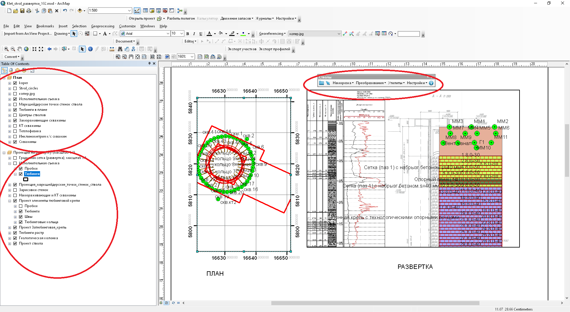
Fig 1. The working window of the
geoinformation
project of the mine shaft sinking
Figure 1 represents the information visualized in the plan and in the
reamer on the right side, while the toolbar of the software module “Shafts” is
displayed on the top.
The maintenance of the system like this makes possible to compare the
data obtained from the results of drilling a control wellbore with the
geological description of sinking a shaft.
Except the data mentioned above, the project contains information about
the nature of the
zatubing
space filler and the
heads` (concrete, plastic concrete) power, the presence of possible screens,
lock covers and other water blocking things used in the construction of
the shaft. It is stored in the attributive tables of the thematic layers. The
tiers of reinforcement along with the depth of the shaft to the lithological
column, stratigraphic and hydro geological horizons were precisely aligned.
There is a full description of the rock mass, opened when sinking the shaft,
features of bedding and structure of the geological layers.
According to the executive survey and geological sketches, the exact
location of the opened cracks and water occurrences is set and fixed in the
project (Fig. 3). Further, these zones will be drawn special attention during
defrosting the mass and the shaft operation.
Thus, this project contains all the necessary information about the
geological environment and the technical characteristics of the shaft.
The data visualization is carried out by the standard, quite powerful
ArcGis
tools. There is a wide selection of conventional
signs (markers, fillers), and if necessary, you can create your own “unique”
map and graph signs using the symbol editing tools. In addition to that, the
program possesses a powerful tool for classifying and grouping visualized
objects according to the characteristics stored in the relational table, as
well as a large set of out-of-frame design elements (coordinate grids, legends
of conventional signs, scale,
orientation
to the
cardinal points.). The following are some illustrations of the thematic content
of the
Gis-project.
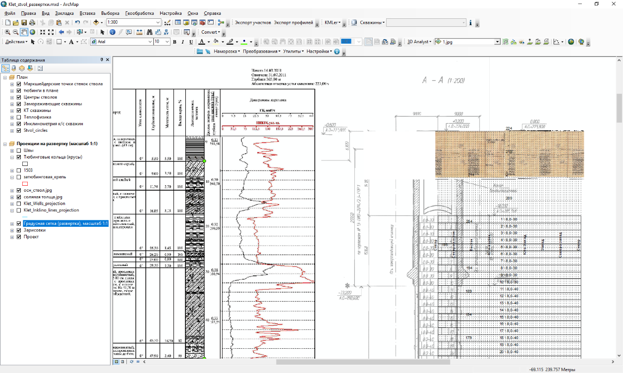
Fig.2.
The
working project general view
of the shaft reamer data storage
Fig.3. Elements of tubing and
zatubing
support
in the reamer
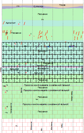
Fig.4.The actual data of geological sketches, fixed
tubings
and plugs
For the 3D presentation of the input data, it was necessary to obtain 3D
geometry with the preservation of attributive data. To facilitate and
accelerate the
convertion
process of the data from
the plane into 3D an additional software module was created. The module makes
possible to convolve the flat data into a cylinder for a given center and a
radius, and to
carry
out a reverse operation, if
necessary (Fig. 5). An additional toolbar appears in the
ArcGis
software environment, which makes possible to convolve and project the data
with the instructed cylinder diameter and its center. It should be noted that
the 3D geometry obtained is stored in the real coordinate system, which gives
the possibility of combining the results obtained with the other data at any
time.
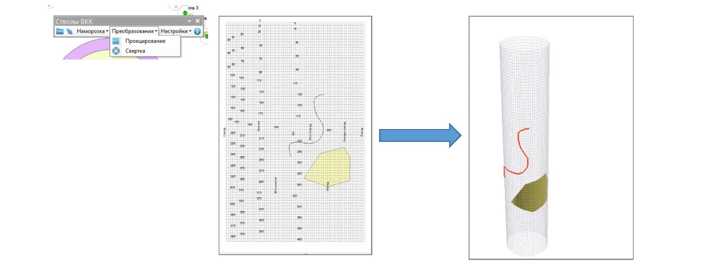
Fig.5.
The
data convolution into a
cylinder
The visualization of the data obtained is carried out in the
ArcScene
application, which also possesses a rich set of
symbols and fillers, which makes possible to group, classify and reclassify the
objects displayed.
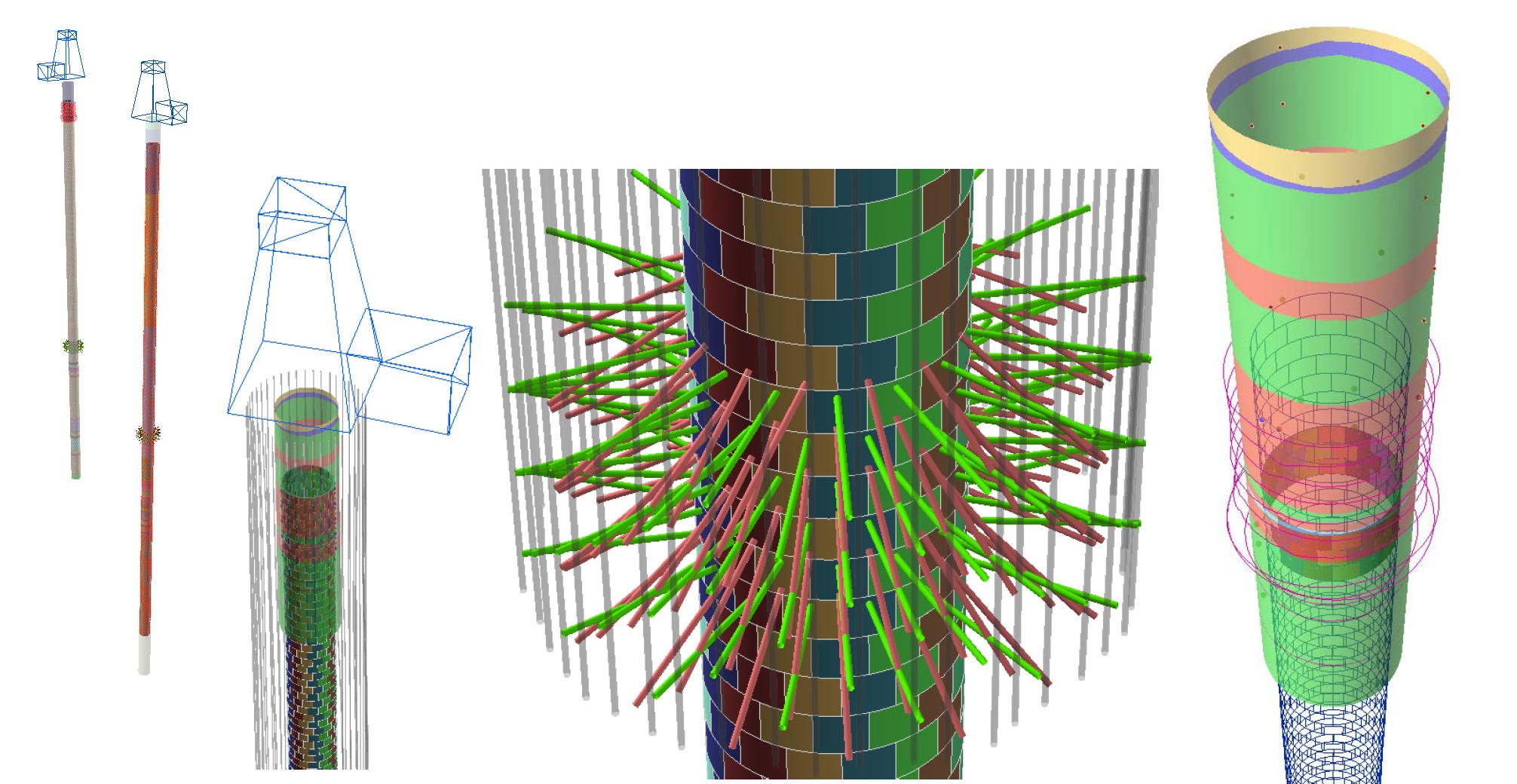
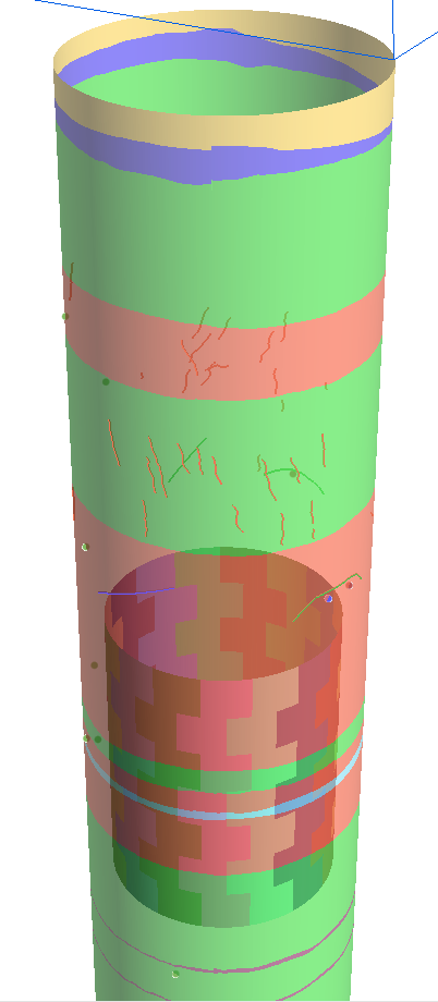
Fig.
6. Different types of 3D data visualization
Fig.7. Convolution of geological sketches - on the left, support and
water protection elements - on the right
Fig.8. Visualization of cracks in a 3D mode and the reamer
The experience of maintaining the system showed that deviations from the
design decisions may happen in the course of sinking the shaft. The types of
tubings
may be changed and shifted. The degree of the
influence of these changes on the safety of the construction operation should
be efficiently assessed. Therefore, the required element of the information
model like this is the 3D visualization of the available data for making
possible to compare the project data with actual results based on the graphical
method (Fig. 9) in order to reveal possible errors and deviations in the
project.
For example, when drilling wells of the
tamponages
curtain, it is necessary to determine if they will cross the axis of the
freezing wells, which in this case will result in the depressurization of the
freezing columns and will lead to an emergency. The joint display of designed
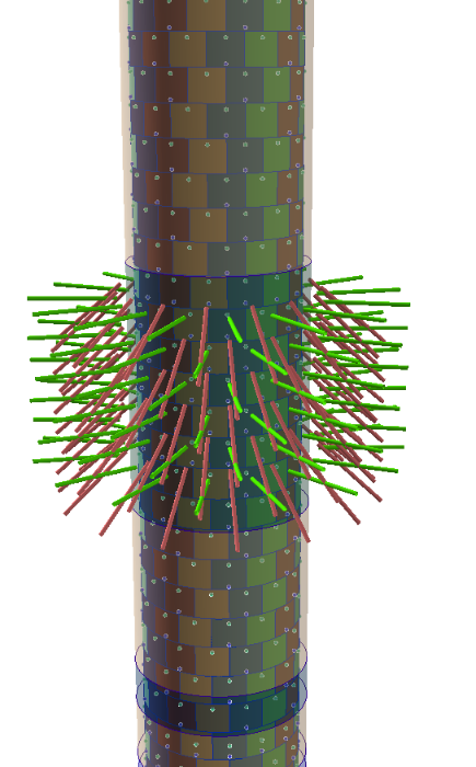
wells and freeze wells is capable of revealing potential risks (Fig. 10).
Fig. 9 The joint presentation of the designed data and executive survey
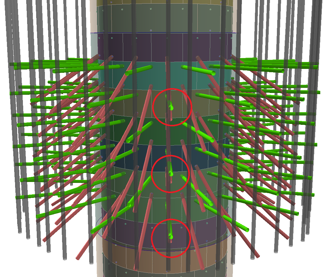
Fig.10. 3D visualization of
tamponages
curtain
wells
In addition to visualizing 3D geometry, the
ArcScene
tool makes possible to create animations of high quality both in view and in
the timeline mode (Fig. 11. Fig.12.). One more advantage of using this software
product is its openness and interoperability with other software
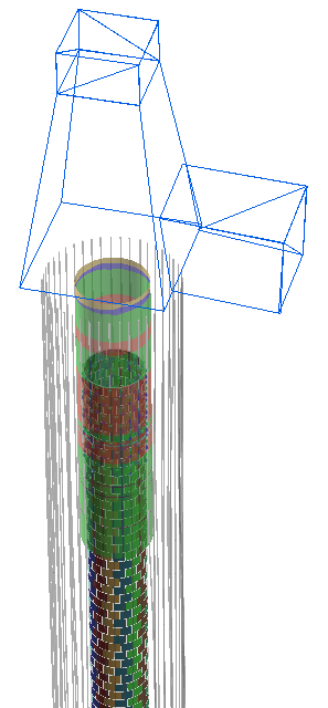
products. Thus, using CAD tools (Autocad Autodesk),
3D geometry of the mine shaft connection places with the transport, ventilation
horizons and the cleaning of the sump (Fig. 11 of the interface) was obtained.
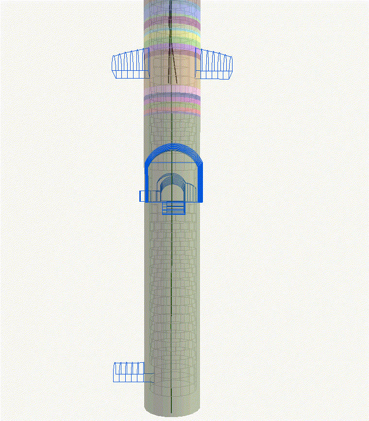
Fig. 11.
3D geometry of the mine shaft connection places with the transport,
ventilation horizons and the cleaning of the sump
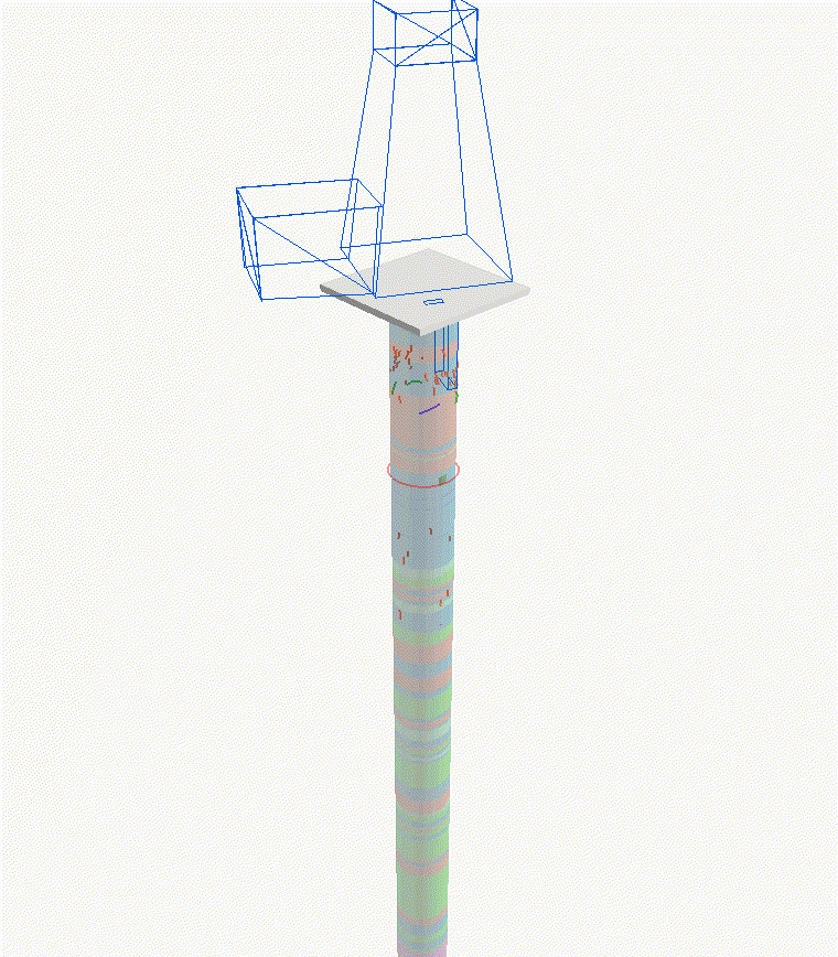
Fig. 12.
An animation in the timeline mode characterizing the order of the
tubing installation into the tubing rings
Figure 12 shows an animation in the timeline mode characterizing the
order of the tubing installation into the tubing rings. It should be noted that
the first 10 rings are installed from bottom to top, that is, 10 -
9 - 8, etc., and then top to bottom 11 - 12 - 13, etc.
The author considers the analytical information system of sinking a
shaft is necessary to be supplemented with photographic materials. The use of
photographs, but not only sketches, spatially tied to the reamer and visualized
in a 3D form may remove questions about the sketches quality, the exact
location of cracks, water occurrence, etc.
The application of the given approach to the simulation of the “Mine
Shaft - Geological Environment” system makes possible to obtain the
information about the mass of rocks in the fixed space and combine it with the
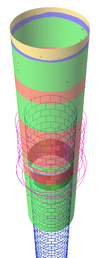
structural characteristics of the construction (Fig. 13).
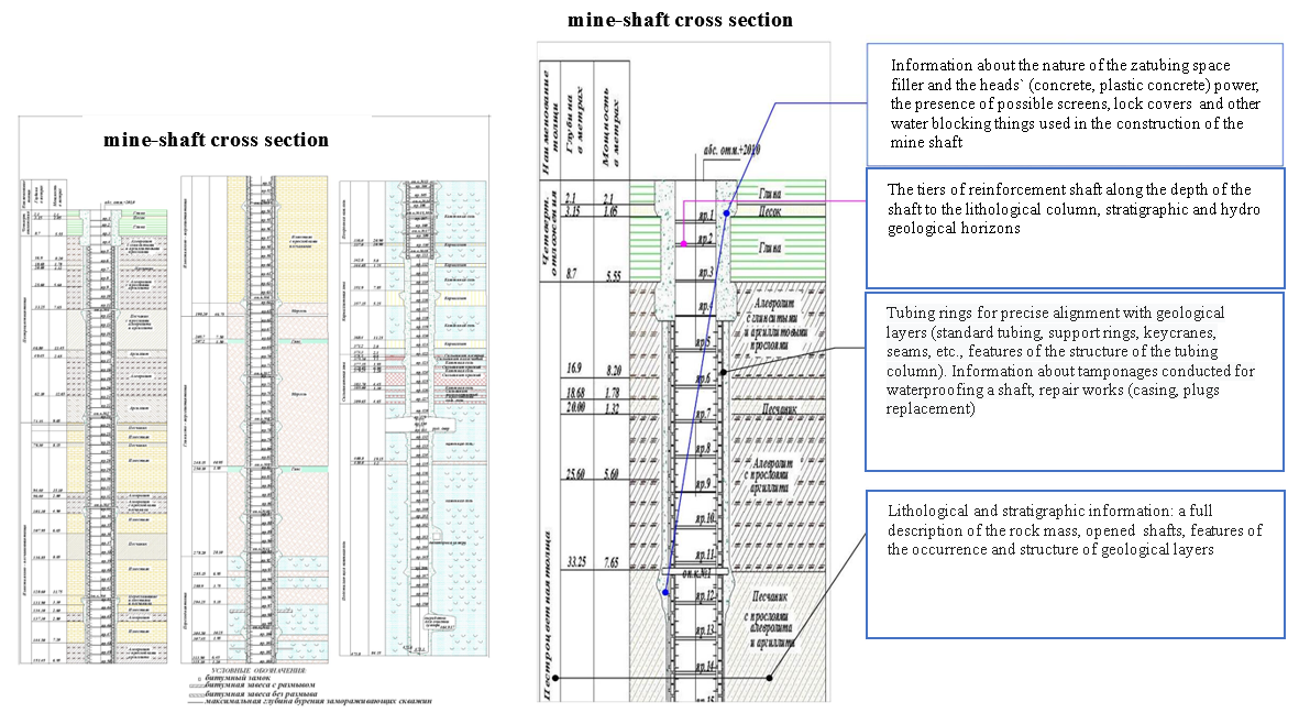
Fig.13.
The
joint presentation of the data in
the system "Geological Environment - Construction"
The technical and methodological solutions for the data grouping by the
two-component natural-technical system “Geological Environment - Construction”
by means of
geoinformation
technologies give the
possibility of accumulating, structuring and making access to the heterogeneous
data to each specialist of the enterprise.
The developed technical solutions provide effective processing,
synthesis and visualization of data at a fundamentally new qualitative level.
The analytical information system created by the author will provide
technical services specialists of the mining enterprise and related research
and design organizations with reliable and efficient information at all stages
of the construction life cycle.
This methodological approach to the geological engineering modeling of
the system “Mine Shaft - Geological Environment” is analogous to the BIM
modeling and is able to reduce the risk of emergencies in the course of sinking
mine shafts as well as during their operation.
The application of the
ArcGis
software product
makes possible both to conduct a spatial analysis of the available data and to
prepare presentation material in a dynamic form (animation).
The 3D visualization of the design and actual data is a means of
additional control of geological mining information entered into the systems
and the design decisions adopted.
1.
Savin
I.I. Experimental and analytical
method for calculating lining according to the results of measurements of
normal tangential stresses // Study of the problems of mechanics of underground
structures, Tula, 1987, p.31-34.
2. Tarasov V.V.,
Pestrikova
V.S. Overview of
emergencies that occurred at the
Verkhnekamsk
potash
deposit during shaft shafting // Mining Information and Analytical Bulletin
(scientific and technical journal). - 2015. - No.5. - S. 23-29.
3.
Kashnikov
A.V. Information-analytical
system "trunk passport" for engineering and technical workers of
mines // Strategy and processes of development of
georesources.
- Perm: Mining Institute of the Ural Branch of the Russian Academy of Sciences,
2011. - S. 251-252.
4. Mineshaft construction // Sight Power URL:
http://sight-power.com/solutions/
mineshaft-construction (accessed: 07/11/2019).
5. Tunneling of vertical shaft shafts // Russian Mining Portal URL:
http://www.miningexpo.ru/useful/4927 (accessed: 07/11/2019).
6. Information-analytical system “Trunk passport” // Federal State
Budgetary Institution Mining Institute Ural Run URL:
http://www.mi-perm.ru/solution/nr?show_id=17 (accessed: 07/11/2019).
7.
Konoplev
A.V.,
Krasilnikov
P.A. A technique for mapping territorial combinations of natural resources and
their comprehensive assessment by a GIS technology (as exemplified by Perm krai)
// Geography and Natural Resources. 2012. –Vol. 33, p
83-86. DOI: 10.1134 / S1875372812010131
8.
Geoinformation
support of the
engineering-geological and geo ecological safety system of the city of Perm /
Konoplev
A.V.,
Kopylov
I.S.,
Krasilnikov
P.A.,
Kustov
I.V. //
Geoinformation
support for the spatial development of the
Perm Territory: Sat. scientific
tr
- Perm: Perm State
National Research University, GIS Center, Perm State Scientific Research
University. 2014. - S. 56-78
9.
Khronusov
V. V.,
Barskiy
M. G.,
Krasilnikov
P. A. Engineering geology software
database for urban areas // International Multidisciplinary Scientific Geo
Conference Surveying Geology and Mining Ecology Management, SGEM. 2018. – Vol.
18 (2.2), p. 163-170. DOI: 10.5593 / sgem2018 / 2.2 / S08.021
10. Three dimensional visualization and analysis of the results of
engineering-geological and geo ecological studies /
Kanya
E.V.,
Dimuhametov
D.M.,
Konoplev
A.V.,
Spassky
B.A.,
Lunev
B.S. // Basic research. - 2014. - No. 9-12. - S. 2708-2712; URL:
http://www.fundamental-research.ru/ru/article/view?id=35420 (date of access:
09.10.2019).
11.
Pikulik
EA,
Mironov
O.K. Data visualization in the process of engineering-geological research //
Sergeevskie
read. The role of engineering geology and
research at the pre-design stages of construction development of territories:
Mater.
Session of the Scientific Council of the Russian
Academy of Sciences on the problems of
geoecology,
engineering geology and hydrogeology.
RAS Publishing
House, Moscow.
2012. S.73-78.
12.
Jia
W., Wang G. Multiple level
prospectivity
mapping based on 3D GIS and multiple geo
science dataset analysis: a case study in
Luanchuan
Pb-Zn district, China // Arabian Journal of Geosciences.
– 2019. - Vol. 12 (11). –P.332
13.
Nugraha,
R.P.,
O'Sullivan, J. A key process of natural state modeling: 3D Geological model of
Jaboi
Geothermal field,
Nangro
Aceh Darussalam, Indonesia // IOP Conference Series: Earth and Environmental
Science. –2019. –Vol. –254 (1) N 012024