There are many examples
of building of images based on text files containing georeferenced data (data
that has map reference coordinates).
For these purposes, at various
times, graphic editors Surfer [2], MathCAD [3], etc. were created, which can
work with input text files and process these files in the form that is
interesting to the user.
In this article, we will not dwell on each of
editors;
the article has a different goal, namely, to show the process of creating an
image from any text file for subsequent display on a Yandex satellite map
without involving well-known powerful graphic editors.
API (abbr. from the English Application Programming
Interface - a description of how one computer program interacts with others)
Yandex [4] has all the necessary functionality for the implementation of this
project, despite some limitations compared to other satellite maps (Google
Maps, for example).
In addition, Yandex is a domestic development, which is of
no small importance.
The authors set themselves the goal of universal image
generation based on a text file that has in its arsenal only the values of a
certain parameter (be it sea surface temperature or the number of visitors to
supermarkets over a period), as well as georeference values
(longitude/latitude) of the parameter.
That is, if we are talking
about the temperature of the sea surface, then the latitude and longitude of
the point at which the temperature parameter takes exactly this value (obtained
from observations or predicted) act as a georeference.
If the
parameter is the number of visitors to supermarkets for the period, then the
file with georeferenced data will use the longitude/latitude of the point with
the location of the supermarket of interest.
In other words,
longitude/latitude uniquely identify the locations of the values of the
parameter that will be shown on the rendered image.
The following assumption
should be noted: - any text file that has not been previously processed by
graphic editors or anything similar, such as files of GRD type (the result of
processing by the Surfer editor or Adobphotoshop [5]), can be used as input.
As a
software tool for the subsequent implementation of image construction, the
scripting programming language PHP [6] was chosen, since it is best integrated
into any site, namely the site with the Yandex satellite map in our example,
where, ultimately, the built image will be sent.
In
addition, PHP has the full range of graphics functions needed to create images.
So, the final goal,
namely the visualization of arbitrarily given georeferenced data, will be
implemented in several steps:
1 black and white rendering of
image,
2 “filling” the constructed
image with color,
3 laying out the image on the
Yandex satellite map.
The input data is a
text file with the CSV extension, consisting of three columns:
- latitude/longitude in
the first two columns;
- the actual value of
the parameter (in our example, this is a truncated geostrophic, that is, only
one of the two velocity components).
In this case, the
extension in the name of the text file matters only so that a function designed
specifically for this extension is used to open this file in the PHP program.
First, let's build a black and white image of the data
contained in the input file.
The black-and-white image is built only on the basis of the
longitude/latitude of those points in which the parameter values are present.
Actually,
the value of the parameter itself will appear at the development stage in step
2, since the parameter values in the figures are actually a color palette,
which we will see later.
The result of the script at step 1 is shown in Figure 1.
The
canvas size is calculated and depends on what is the maximum number of points
in the input file represented by latitude and longitude:
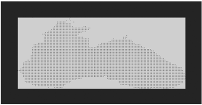
Figure 1.
Primary black and white image of the input data
x = (max_do - min_do)* const,
y = (max_sh - min_sh)*const,
where:
max_sh, min_sh –
values of maximum and minimum latitudes in the input file,
max_do, min_do -
the values of the maximum and minimum longitudes in the
input file, respectively,
const –
an arbitrary constant that specifies an increase / decrease
in the image to improve viewing (a kind of scale).
In order to get the
same image in a solid black and white representation, you can use the constant
const, reducing our result, and see the image on the screen, see Figure 2.
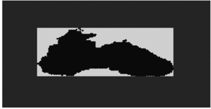
Figure 2.
Primary
image
of
input
data
in
solid
black
and
white
representation
To clarify, points are
clearly visible in Figure 1, but nevertheless, to construct them, the function
for constructing an ellipse imagefilledellipse () was used with black (temporarily)
as a fill color.
The point in this case acts as a particular of the ellipse,
that is, the point with equally given sizes of radii is considered an ellipse
(functionally more universal).
In the PHP script, in
addition to the above, the following functions were also used in step 1:
imagecreatetruecolor()
–
creating an image of a calculated size
,
imagecolorallocate()
–
creating colors (white for building
drawings on canvas and black for filling dots-ellipses),
imageFilledRectangle()
–
building a white rectangle on the canvas
as the background of the image.
At this point, step 1 is considered fully
implemented.
At this stage, we will additionally use the text data of
the same file, but with an arbitrary palette file of the RGB type, that is, the
palette file contains three columns corresponding to the values Red, Green,
Blue.
For now, for clarity, we will build the palette directly on
the same canvas created earlier in step 1. To do this, we increase the size of
the canvas calculated in step 1 by the desired width of the palette:
-
x = ((max_do - min_do)
+ const_add_palett)* const,
where
const_add_palett –
the desired width of
the palette image (for example, from 0 to 10).
Zero in this case means no
palette on the canvas.
So, it is necessary to paint over each point of the
original black-and-white image with the color from the palette that corresponds
to the parameter value at the point with the specified longitude/latitude.
To
establish this correspondence, we will proceed as follows:
-
count the total number of points with parameter values (in
our
example 2993) and the total number of lines with color values in the palette,
for example 150;
-
since there are significantly more points with parameter
values than colors in the palette, 2993 versus 150, and when choosing other
input data in the future, this excess will remain unchanged to one degree or
another, we will determine by simple calculations which color the range of
parameter values from the input data will belong to;
-
in the imagefilledellipse() ellipse construction function
specified in step 1, change the fill color from black to the color of the
parameter, the correspondence to which we have already determined above.
Figure
3 shows the output of the updated PHP script, displaying the used palette of
different widths (left and right), as well as indicating the maximum and
minimum values of the parameter corresponding to the start and end colors of
the palette.
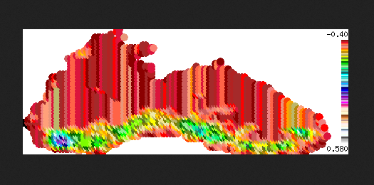
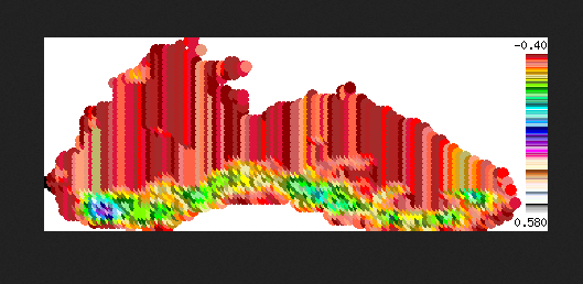
Figure
3.
Color image with a palette of different widths
and inscriptions
It should be noted that
the indications of several parameter values, in addition to the maximum and
minimum, can be specified in different ways - either by the corresponding
inscriptions-divisions at the palette scale itself, or as a "pop-up"
hint when "removing" these values from the canvas, similarly to
"removing"
coordinate values on the Yandex satellite map [7], about
which certain assumptions should be made in the future.
In the PHP script, in
addition to those already used earlier in step 1, the following functions were
used in step 2:
imagecolorallocate()
–
creating different colors to build a
palette,
imageFilledRectangle()
–
building a rectangle on the canvas with
all colors as a palette,
ImageString ()
–
to create inscriptions on the palette
image.
The first two steps will be considered preliminary before
laying out the generated image on the Yandex satellite map [8].
In the finished image,
before laying it out on the map, one more thing needs to be done - a
transparent background.
But since this requires adding only one function
Imagecolortransparent() for the background color (in our example, it is white),
and the result of this function’s work appears best after it is laid out on the
map, it was decided to add transparency to the image at step 3 - when
laying
out on a satellite map.
Let's
insert
the
finished
PHP
script
for
building
the
image
into
the
HTML
frame.
Let's transfer the already finished image
with the necessary parameters (coordinates of points with the parameter, the
center of the future map, etc.) to the JS script [9], since it is JS that is
responsible for building the Yandex satellite map.
As a
result, we get the image
shown in Figure 4.
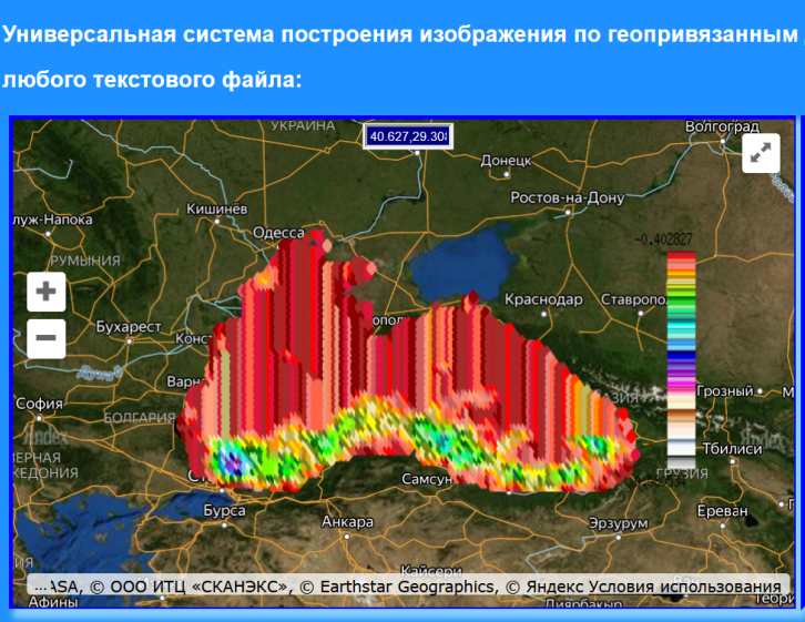
Figure
4.
Image
on
Yandex
satellite
map
Now that everything is ready, as an experiment, let's try
to replace the palette file, using a palette with a small number of colors for
this.
Then the same image [10] will look as shown in Figure 5.
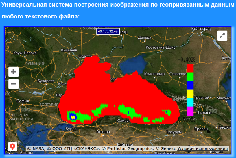
Figure
5.
Image on the Yandex
satellite map with a different palette
In other words, in the future, the user himself will decide
and accordingly choose which palette is more convenient for him to use.
Finally,
Figure 6 shows an example of the image of the temperature averaged over a
decade (as a parameter) of the surface of the World Ocean on the website of the
Hydrometeorological Center of Russia [11], made by completely different means.
This
example can be done with our fairly simple method described in the article.
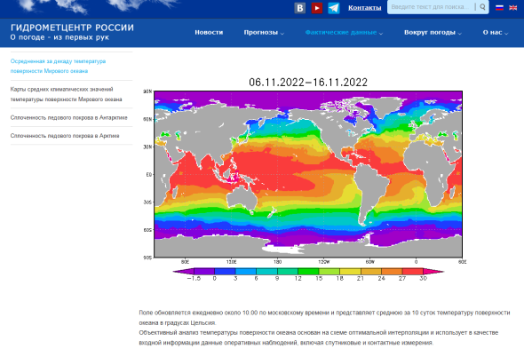
Figure
6.
Actual data from the
Hydrometeorological Center of Russia
Note that these works with step-by-step imaging were
carried out by a somewhat unconventional method, that is, the program was
debugged not by separate modules, but each new step included the previously
debugged one, that is, a certain kind of “stringing” took place.
Thus,
it was this approach that made it possible to reach the final goal with an
already fully debugged, working PHP script.
This pivotal, working script will serve as the main basis
for our further works
towards universality.
Note that this further works
are already underway.
Universality will consist in the ability to select any text
file, as well as a file with a palette.
In the future, we will make
the palette image separate from the main image in order to be able to place the
palette image anywhere behind the map vertically or horizontally at the request
of the researcher.
And most importantly, we have to make a software product
for constructing the speed parameter, that is, arrows will be drawn on the
image indicating the direction of movement of high-speed flows.
I must
say that all future results will be reflected in the article, which will be a
continuation of this article.
If we turn to examples of the global level, then on the
COPERNICUS website [12], where a huge number of images of geophysical
parameters are presented, we note that the software product can also be used in
analogue systems of Copernicus.
Also, this software product can become the basis for works
in any region on the cartographic surface.
On the site with the Yandex
map, in the future it is planned to create various kinds of selections of input
data and palettes of interest, which will form the basis of the topic for
another article.
The work was carried out
within the framework of the state task on the topic FNNN-2021-0004
"Fundamental research of oceanological processes that determine the state
and evolution of the marine environment under the influence of natural and
anthropogenic factors, based on observation and modeling methods" (code
"Oceanological processes").
1.
Voronina N. N., Inyushina N. V., Mamchur N. L.,
Kryl' M. V.
Analiz i sopostavlenie programmnyh sredstv vizualizacii morskih prognozov
na osnove raschetnyh dannyh operativnoj okeanografii po chernomorskomu bassejnu
na primerah sevastopol'skogo i krymskogo regionov.
// Nauchnaya
vizualizaciya.
Elektronnyj zhurnal, ISSN 2079-3537, № 1, T. 8, 2016. –
s. 146 - 155.
[Electronic resource]. URL:
http://sv-journal.org/2016-1/09.php?lang=ru
2. Dogan T., Kastner P., Mermelstein R. Surfer: a fast simulation algorithm to predict surface temperatures and mean radiant temperatures in large urban models // Building and Environment. 2021. Т. 196. С. 107762.
3. Nikulin Ye. Kompyuternaya 2d-grafika. Programmirovanie v MathCAD// Lan, 2022
4.
Koptenok
Ye.
V.,
Savenko
A.
V.,
Fomin
I.
I.,
Trunnikov
M.
V.,
Sukharev
Ye.
A.
Analiz
vozmozhnostey
servisov
dlya
realizatsii
virtualnykh
turov
na
primere
ispolzovaniya
API
Yandeks.
Kart.
//
Molodoy
uchenyy. № 19
(309), 2020. - S.130-133. URL:
https://moluch.ru/archive/309/69891/
5. Folkner E., Chavez K. Adobe Photoshop SS. Ofitsialnyy uchebnyy kurs // Eksmo-Press, 2021.
6. Zandstra M. PHP 8. Obekty, shablony i metodiki programmirovaniya // Dialektika, 2021. [Electronic resource]. URL: https://php.ru/manual/
7.
[Electronic resource]. URL:
http://innovation.org.ru
8.
Mokhov V.A., Kubil V.N.,
Kuznetsova A.V., Georgitsa I.V.
Rekursivnyy algoritm sinkhronizatsii
Api-zaprosov k gis-servisu Yandeks.Karty
//Fundamentalnye issledovaniya. №
9-1, 2015. – S. 33-38.
URL:
https://fundamental-research.ru/ru/article/view?id=38961
9.
Foerderer J., Bender M., Heinzl A.
Regulation of digital platform
ecosystems: evidence from russia's google vs yandex ruling.
//
V
sbornike:
International Conference on Information
Systems 2018, ICIS 2018. 39. 2018.
10.
[Electronic
resource]. URL:
http://innovation.org.ru/generate_image_do-sh.php
11.
Servis Programmy «Gidromettsentr
Rossii» //
[Electronic resource]. URL:
https://meteoinfo.ru/ocean
12.
Servis Programmy «Kopernikus» //
[Electronic resource]. URL:
https://data.marine.copernicus.eu